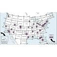
Sectional Aeronautical Charts are the primary navigational reference medium used by the VFR pilot community. The 1:500,000 scale Sectional Aeronautical Chart Series is designed for visual navigation of slow to medium speed aircraft. The topographic information featured consists of the relief and a judicious selection of visual checkpoints used for flight under visual flight rules. The checkpoints include populated places, drainage patterns, roads, railroads, and other distinctive landmarks. The aeronautical information on Sectional Charts includes visual and radio aids to navigation, airports, controlled airspace, restricted areas, obstructions, and related data. These charts are updated every six months, most Alaska Charts annually.
W**.
Ipad with foreflight is a way more better option.
Well...this is a sectional... I bought it for my checkride, but I don't use in paper a long time. Ipad with foreflight is a way more better option.
J**Y
Thanks
Sent me the current chart, but I didn't realise it was about to expire. Will make for a nice wall poster. Any aviator should have one of these to hang!
T**S
Fast shipping, as described. Sectional chart
Fast shipping, as described. Sectional
H**N
Up to date and quick shipping.
Yep worked and was up to date.
B**I
Newly revised map
It's a map and very up to date as it should be
E**Z
New York Sectional
Sectional charts are required during flight planning and I got this for the New York Area.I recommend to everyone.
J**E
Five Stars
Came quickly, and was actually the most up to date Sectional available (2014)! Thanks!
A**M
Five Stars
fast delivery, newest edition
Trustpilot
4 days ago
1 week ago